
December 28, 2006 - Cloud line along West Africa coast
 |
|
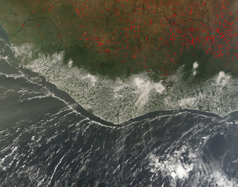
Many fires are visible in this MODIS Terra image of Western Africa, captured December 17, 2006. The fires, represented by red dots on the image, are likely agricultural in nature, and are predominantly in the countries of Guinea (left), the Ivory Coast (middle) and Ghana (right). There are are also some fires north of these the Ivory Coast in Mali and Burkina Faso. They are creating a great deal of smoke, which is mingling with the clouds over and off the coasts of Sierra Leone and Liberia, both west of the Ivory Coast.
Haze and plumes of smoke are visible over the water, as is a thin line of clouds that follows the line of the coast. This could be due to condensing moisture from ocean currents, which can sometimes create clouds that stay uniformly in position above that current for months at a time.