|
|
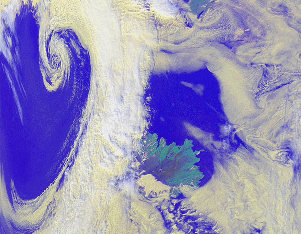
The reason for selecting this image, however, is rather to illustrate how
sophisticated data processing can make subtle cloud structures visible
from a mass of digital data. On the left, the existence of a low
pressure zone is betrayed by a large, elegant counterclockwise spiral.
On the right, a collection of stratiform clouds which are typical for polar
and subpolar regions in summertime are being pushed and pulled into complex
shapes by local atmospheric currents. These clouds strongly influence the polar
energy budget and are a good indicator for such dynamics in the lower
troposphere as eddies, or wave patterns like those in the cloud wedge north of
Iceland. Though long predicted by theory, such large scale structures are hardly discernible
from the ground, and it is only thanks to satellite earth observation that
it is regularly possible to discover and analyze them.
For a higher resolution image click here. (~890k)
AVHRR measures radiance in five channels from visible red to thermal
infrared at a spatial resolution of 1 to 3 km. This image made use
of solar spectral channels 1 (visible red) and 2 (near infrared), where
reflected solar irradiance dominates, as well as channel 5 (thermal infrared,
where the heat radiated from the earth can be measured) to generate a color
composite showing both reflection characteristics and cloud surface
temperatures. These channels were chosen to make it possible to distinguish
relatively high (white) clouds from clouds which are relatively
lower and warmer (yellow), in a color composite which looks as "natural" as
possible. If the goal had been instead to indicate where precipitation can be
expected, then AVHRR channel 3 (mid-infrared) would also have been used, in
order to bring out the presence of high level clouds with ice tops,
since outside tropical regions significant amounts of precipitation are always
correlated with such clouds.
Several processing steps are required at DFD in order to represent the data at
this level of detail. A mix of commercial and public domain software
was used, as well as the software package APOLLO.
![]()