Time, Tides, and Human Activities
This image showing part of Germany's Elbe River estuary illustrates how remote
sensing data can be used to monitor changes in topography. Data from scenes
recorded by the Synthetic Aperture Radar on board the European Remote Sensing
satellites ERS-1 and ERS-2 over the course of five years have been suitably
processed and combined at DFD into one image. The red line indicates the water
level on August 3, 1992, the white line the situation on March 22, 1995, and
the blue line on February 8, 1997, all at comparable tidal situations. This
information has been superimposed over a topographic model of the area derived
from shipboard measurements in 1992 and with a color bar indicating depth.
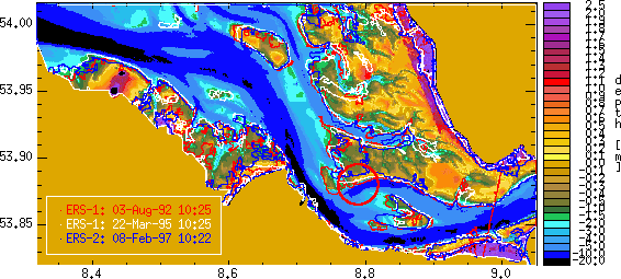
The three horizontal lines in the red circle indicate that the 1992 radar data
closely correlate to the 1992 ground measurements. The white line indicates
the extent of erosion of the Medem Sand sandbank that had taken place by 1995,
and the blue line the status in 1997. This changing situation has implications
for a wide range of activities in the area, from the protection of economically
significant shipping channels to the protection of environmentally sensitive
tidal zones.
This image is one of the early results of a German project to investigate the
usefulness of satellite radar data to monitor the effects of natural and human
activity in a dynamic tidal zone.
Additional information:

This is a service of the German Remote Sensing Data Center (DFD)
Copyright © 1997, German Aerospace Center (DLR)
http://www.dfd.dlr.de:80
/app/iom/1998_05/index.html