|
|
For this purpose, data from three channels of the Thematic Mapper instrument on LANDSAT 5 were georeferenced and combined at DFD into a false color composite: Data from channel 3 (which records visible red) appears blue on the screen, channel 4 (near infrared) appears red, and channel 5 (mid-infrared) green. The latter two channels are especially sensitive to green vegetation, since chlorophyll is highly reflective in the infrared part of the spectrum.
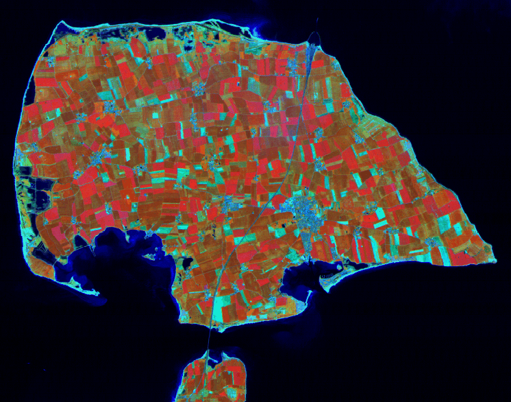
The noticeable line curving across the island is a four-lane roadway connecting a bridge to the German mainland at the bottom of the image to the busy harbor of Puttgarden in the north, whose offshore walls are just visible. The orange squares are crops, mostly rape or grains such as wheat and sweet corn (the latter appearing browner, since growth had just started when this image data was collected on May 5, 1995). The bright red areas contain vigorously growing vegetation and are primarily grassland and swamps. In this particular composite, all the areas without vegetation appear in light blues and may either be sealed, built up areas such as the town of Burg located southeast of the roadway and to the north of a lagoon and harbor, or beaches and dunes, such as on the island's northern and western shores. The dark blue areas nearby are important coastal biotopes consisting of small lakes and brackish-water lagoons. The somewhat lighter blue areas of the western part of the south coast are submerged shallows which surface whenever the tide is out.
This image was processed as part of a current European Union project to optimize change detection techniques for use in landscape research and planning in the German state of Schleswig-Holstein and in Denmark. Information about these activities may be obtained
- by consulting the MOBIO project page
- or by contacting Dr. Stefan Weiers by E-mail at DFD in Cologne at
Stefan.Weiers@dlr.de.
![]()