Watching a Forest's Recovery
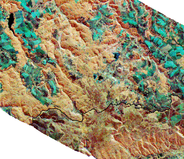
This month's image shows a multifrequency image created from data collected
during the joint U.S./German/Italian SIR-C/X-SAR shuttle mission in October
1994, covering the eastern Ore Mountains (German Erzgebirge) around the
township of Altenberg. The border to the Czech Republic is shown in black
for ease of orientation.
In the high altitude areas of these mountains, the forest had suffered severe
stress from industrial pollution, especially sulfides, resulting in large areas with
damaged and dead wood in the mid-to-late 1980's. At the end of that decade,
a large reforestation program was started southwest of Altenberg (white areas
in the image center) and in other forest areas. In this false color image,
old forest, mainly spruce, is shown in orange and light brown, regrowth and
open forest areas in tones between dark brown and dark green, and
agricultural areas in dark blue-green.

Multifrequency SIR-C/X-SAR data are being used to assist vegetation
mapping in the framework of a forest regeneration program, within a
cooperation project between DLR-DFD, the GAF company, and the Saxon State
Institute for Forestry. These activities supplement an available forest damage
map based on Landsat TM data, where a differentiation of the young forest
states was quite difficult to achieve. The evaluations of forest situation and
regeneration are part of DFD's XEP project to demonstrate applications for
SIR-C/X-SAR data in vegetation mapping, coastal management and structural
geology studies.
This geocoded, terrain-corrected SIR-C/X-SAR image is a combination of L-band
(HV polarization), C-band (total power) and X-band (VV polarization) in red,
green and blue.
For more information

This is a service of the German Remote Sensing Data Center (DFD)
Copyright © 1997, German Aerospace Center (DLR)
http://www.dfd.dlr.de:80
/app/iom/1998_12/index.html
