|
|
The two images below illustrate the problem by showing the same scene before and after atmospheric correction. They show NDVI values (Normalized Difference Vegetation Index, a ratio often calculated to quantify the "greenness" of a pixel as an indication of the presence of vegetation) for Germany, generated at DFD from AVHRR sensor data (the Advanced Very High Resolution Radiometer on board NOAA weather satellites). The uncorrected image data on the left results in a significant falsification of NDVI.

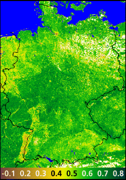
This correction is critical, since NDVI is an essential parameter for a wide range of applications for satellite earth observation data. For example, it is used to calculate the leaf area index, an important indicator of the bioemissivity of plants and of the capacity of plants to intercept precipitation. As an indicator of chlorophyll activity and plant health, NDVI plays a key role in models and analyses of the earth-atmosphere system.
The extensive and complex calculations required for atmospheric correction also include the input of ozone values recorded by the GOME sensor, water vapor values from TOVS data, aerosol data, and information derivable from satellite orbit parameters. This entire procedure is being optimized at DFD so that it can be carried out rapidly and automatically. The goal is to provide the user community with atmospherically corrected up-to-date NDVI values for all of Europe, every day, over the Internet. Later, after the launch of ENVISAT in 2000, the requisite ozone, water vapor and aerosol values will all come from sensors on that satellite.
Information about this service and the image processing may be obtained by
contacting Mr. Thilo Erbertseder by E-mail in Oberpfaffenhofen at
Thilo.Erbertseder@dlr.de
![]()