![]()
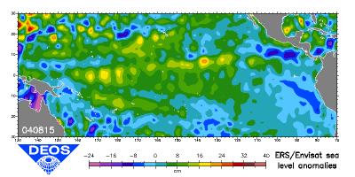
This image shows the real-near-time
variation of the sea level anomalies over the Equatorial Pacific
Ocean.
Here, El Niño induces a relatively high sea level
along the west coast of Central America accompanied by a radical
switch of the regional climate with heavy rainfall. The most recent
snapshot shows that the sea level has returned to its normal level.
The
satellite radar altimeters on board the ERS and Envisat Satellites
have been measuring sea surface heights since July 1991.
Each
image is acquired weekly over a 40-week time window.
Source:
DEOS
(Department of Earth Observation and Space Systems, Delft University).
zurück über den Browser