![]()
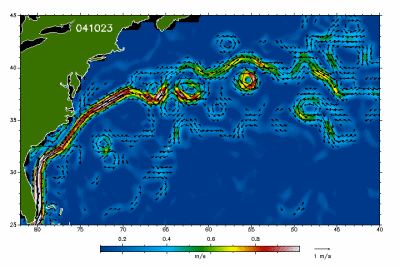
This image shows the variation of
the Gulf Stream velocities near the East coast of North America
in the last 20 days. The images are updated daily and the velocities
are in metres per second (to get the approximate velocity in knots,
multiply by 1.9438445).
Since 22 July 2003 the Gulf Stream
velocity fields derive from near-real-time radar altimeter data
of the European Environmental Satellite Envisat. At the same time
the mapped area was increased to show more upstream regions of the
Gulf Stream.
Source: DEOS
(Department of Earth Observation and Space Systems, Delft University).
zurück über den Browser