![]()
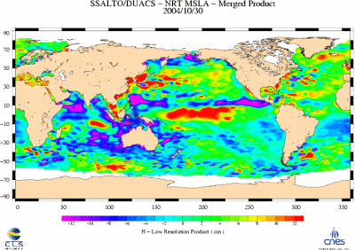
This image shows the variation of
Sea Level Anomalies on a global scale. Duacs,
the Ssalto multimission altimeter data processing system, creates
maps every Wednesday and Saturday.
Sea Level Anomalies are
departures of the sea surface from some long term mean.
Positive
anomalies indicate more heat content (warmer waters, a deeper thermocline)
whereas negative anomalies indicate less heat content (cooler waters,
a shallower thermocline).
Generally, sea level is higher
than average in the northern hemisphere in July and August when
waters are warmed by more direct solar radiation and is lower than
average in February and March when the incoming solar flux reduces.
These
sea level anomalies maps derive from a combination of data coming
from altimeters on-bord Jason-1 and Envisat. Combining data from
several satellites gives a better space/time resolution, thus enabling
a better mesoscale circulation observation. More information can
be found at Aviso.
Source: CNES
(Centre National d'Etudes Spatiales); CLS
(Collecte Localisation Satellites).
zurück über den Browser