Einzelbeispiel satellitengestützter Erderkundung
Hochwasser in Bangladesh
Bangladesh
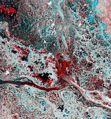
The image centered some 50 km west of Dacca, the capital of Bangladesh, shows the area of the confluence of the Bramaputra/Jamuna (top to down) and the Ganges (right to left) rivers.
The scene is a part of the huge alluvial plain what is being built up as a result of the continuing erosion forces in the Himalayans. There are an enormous number of river courses with form a patchwork of linear elements similar to a muscle nourished by thousands of blood vessles. Main crop in this region is jute and rice.
Two ERS-1 SAR scenes have been combined, namely acquisition of 24 July 1993, displayed in cyan and acquisition of 28 August 1993 displayed in red. The colour combination permits to map changes in the land cover which in this period are linked to flooding. Thus the red colour indicate areas which were flooded on the first date while cyan show the extension of floods just on the second date. Black means flooded at both dates. White or gray reveals no change between the two dates.
The bright spots, e.g. in the upper left corner are villages standing out of the flooded rice fields, and are better visible in the subset of the figure. In the right corner the reddish area is a tropical forest which was much wetter on 28 August than on the other date. The cyan colour nearby show an extended flooded area, probably accidentally, since jute is grown there.
The different colours of the water of the rivers is difficult to explain. It might well be influenced by weather phenomena such as a thunderstorm that was active during the acquisition, with gusty winds roughening the water surface in places. It has to be investigated whether the confluence of two different waters would create turbulence, that would result in higher roughness as it can be observed on the image downstream of the confluence.
Image details:
ERS-1 SAR
orbit 10570 frame 3123 date 24-Jul-1993 at 04:35:00 GMT
orbit 11071 frame 3123 date 28-Aug-1993 at 04:35:00 GMT
Acquired by the Bangkok/Thailand ERS-1 receiving station, processed by the German Processing and Archiving Facility at DLR, Oberpfaffenhofen.
Post-processing at ESA/ESRIN
(ERS Utilization Section ESA/ESRIN)
Quelle: ERS Spaceborne Radar Imagery, Copyright ESA 1996
![]()