Einzelbeispiel satellitengestützter Erderkundung
An der Bucht von Gaeta vor Neapel
Gaeta
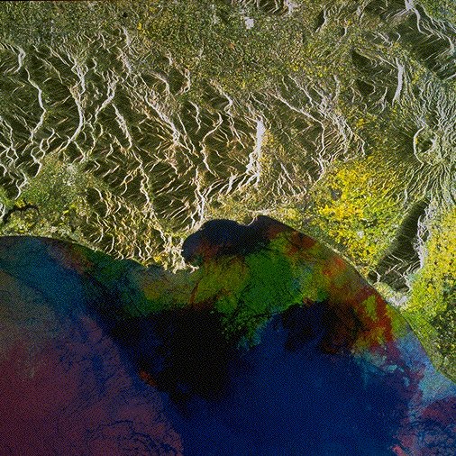
The first multitemporal image including both ERS-1 and ERS-2 SAR data. It has been acquired over the central Italian Tyrhenian Coast on the following days:
27 March 1995 (displayed in blue) from ERS-1
1 May 1995 (displayed in green) from ERS-1
2 May 1995 (displayed in red) from ERS-2.
The image shows the Tyrhenian Coast with the city of Gaeta on the Cape near the image center. Mid-top is situated the other larger town within the image: Cassino. It can be found on the foothills just east of the very bright patch, an industrial site. The mountains include the Aurunci to the west and the Mainarde to the north with the Valle del Liri in-between. To be noted is the well outlined volcanic crater including a secondary cone, visible mid right, close to the edge of the image: the Roccamonfina volcanic edifice.
In this multitemporal SAR image little changes on the land can be expected. The general slightly yellow color tone may be explained by the more advanced vegetation period at the beginning of May with respect to end of March. The colourful sea results from the changing wind conditions.
ERS Data Utilization Section, ESA/ESRIN
Quelle: ERS Spaceborne Radar Imagery, Copyright ESA 1996
![]()