Einzelbeispiel satellitengestützter Erderkundung
Relief in der Vollwüste
Sahara
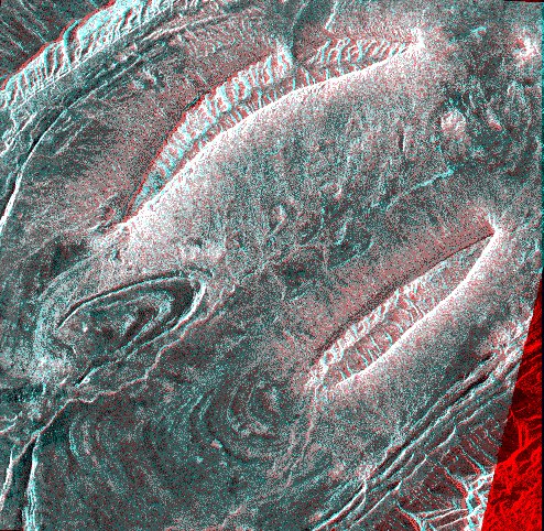
Two ERS-1 SAR scenes are used:
- orbit 4304 frame 2943 of 12 May 1992 displayed in cyan (green and blue)
- orbit 5034 frame 2943 of 2 July 1992 displayed in red with an orbital longitudinal shift of 18.6km have been superimposed for a small common area to generate a stereoscopic pair. In order to experience the 3-dimensional effect one has to view it with a pair of red (right) and blue (left) glasses.
The area is centred about 33-5N, 0-10E in the Sahara Atlas, some 50km south of the Chott ech Chergui. The settlement of Chellal Dahrania is situated towards the left edge and is visible as few bright points.
For a geologist it is easy to recognise three anticlines: in the top-left and the bottom-right corners and mid-left of the image. Even more conspicuous are the two synclines, which stands up very clearly as table mountains, viewed in stereoscopy. Note that the northern syncline is broken-up and its inner-valley is drained towards north.
Judging from the relative position of the fold-axis one can assume two stages of tectonic activity, first the folding of the sediment layers and second the relative movement of the axes. The anticline axis running southwest-northeast through the centre of the image dips towards northeast and explains the relative higher position of the two synclines on either side.
(ERS Data Utilization Section ESA/ESRIN)
Quelle: ERS Spaceborne Radar Imagery, Copyright ESA 1996
![]()