Einzelbeispiel satellitengestützter Erderkundung
Schott el Djerid, Salzwüste
Chott el Djerid
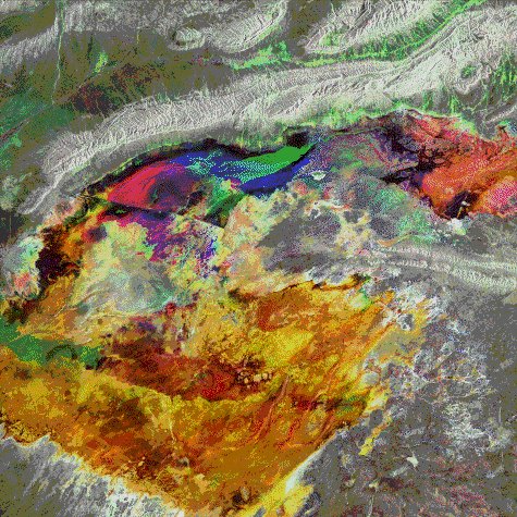
The Chott el Djerid in south central Tunisia is a large playa or dry salt lake that forms one of the zones of such Chotts through Tunisia and Algeria. Part of the easternmost of these, the Chott el Fedjadj, can be seen in the north-east corner of this image which is a multitemporal composite of three dates of ERS-1 SAR acquisition: 29 May 1992 (blue), 7 August 1992 (green), and 16 October 1992 (red).
The Chotts are the surface expressions of basins of sedimentary rock, millions of years old that have formed at the boundary between the stable Saharan platform to the south and the currently deforming Atlas fold mountain chain to the north. These fold mountains can be seen in the northern part of the image, whilst the northern limit of the Grand Erg Oriental sand sea can be seen in the southwest of the image.
G. Wadge, NERC, University of Reading, UK
Quelle: ERS Spaceborne Radar Imagery, Copyright ESA 1996
![]()