Einzelbeispiel satellitengestützter Erderkundung
Ätna auf Sizilien
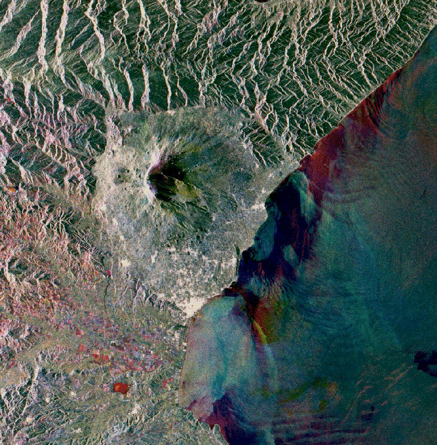
Etna
The multitemporal ERS-1 SAR scene represents about 100 by 100 km and is composed of:
Red: 1 Nov 1992
Green: 10 May 1992
Blue: 14 Feb 1993
Surrounded by hills the cone of the volcanic edifice of Etna is situated near the centre of the scene. To the east is the Ionian Sea. Noticeable are the many internal waves, they often occur in this region as a result of the tidal flow through the Strait of Messina.
This image offers another opportunity to demonstrate the geological and geomorphological mapping potentials of the SAR. The different lithological units encircling Mount Etna are astonishingly easy to separate. To the north and northeast the metamorphic crystalline of the Peloritani is very different from the Capo d'Orlando Flysch present towards the upper-right corner, and yet different in appearance are the hills to the west of Mount Etna consisting of soft argillaceous layer and of Numidic Flysch.
Also on the flanks of Etna interesting details are revealed, such as the many small lateral craters and the particular shape of the volcano due to the collapsed eastern part that forms the Valle del Bove. Faults and earth crevasses are of particular interest to specialists: several of them are visible as bright lines on the southern slope and as rather thick black linear feature on the eastern slope. Well imaged by white patches and spots is also the densely populated area especially on the lower part of the southeastern slopes towards the town of Catania.
The dark cap of Etna marks the area of constant ash fall where vegetation is very scarce. On the summit of this fast changing volcano, some of the principal craters are well visible. The overall greenish colour in the image indicates a higher soil moisture on 10 May with respect to the other acquisition dates. Only few of the many lava flows emanating radial down the flanks are visible.
To improve their perception, image enhancement techniques and combined analysis with optical/infrared data is recommended. The very fresh lava from the 1991/92 eruption which partly filled the bottom of Valle del Bove appears in bluish colour and with a particular texture.
Agricultural land in the Simeto-Valley (south of Etna) and on the gentle hills to the west include quasi all possible colours due to the high diversity of farming practices (field crop and fruit-trees, some rain-fed others irrigated).
(ERS Data Utilization Section, ESA/ESRIN)
Quelle: ERS Spaceborne Radar Imagery, Copyright ESA 1996
![]()