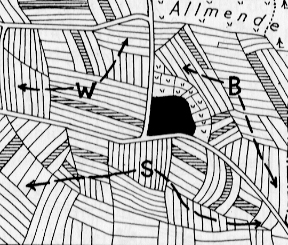
Flur und Gemarkung, Flurformen
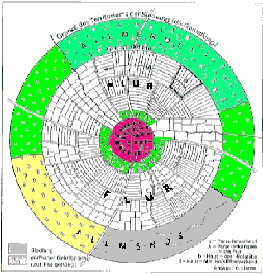
Gemarkung ist die gesamte Wirtschaftsfläche einer Siedlungsgemeinschaft. Sie gliedert sich in
- Flur,
das ist der individuell
genutzte Raum, z.B. Garten, Acker, Wald
- Allmende,
das ist die gemeinschaftlich
genutze Fläche, z.B. Wald, Weide, Waldweide, Dorfanger
Das Territorium einer ländlichen Siedlung
|
|
Die Ringe von
außen nach innen: |
Flurformen
Die Art der Parzellierung einer Flur legt die Begriffe aus der Flurformenlehre fest:- Größe und Lage
- Umrißgestalt
- Nutzungsart
- Besitzzugehörigkeit
Flurformen entstehen
in Abhängigkeit
– von der Besitznahme
(Initiative, Rechte),
– von sozialer
Abhängigkeit der
Bewirtschafter,
– vom Erbrecht
der Besitzer.
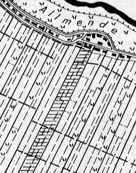
Flurformenbeispiele
- Block-
oder Streifenflur,
hier ist die Form ausschlaggebend
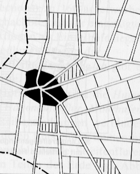
- Einödflur
oder Gemengeflur,
hier sind die Besitz- und Nutzungsrechte im Vordergrund der Überlegung
- Hufen- oder
Gewannflur
weist auf die Art der Landvergabe hin
Blockflur
|
Streifenflur
|
Einödflur
|
Gemengflur
|
Hufenflur
|
Gewannflur
|
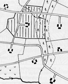
Osnabrücker Land: Welche Flurform?
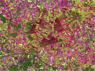
Zoom!
Ob
hier in der Mitte die Varusschlacht wirklich stattgefunden hat?
Kalkriese
hat dazu ein eigenes Museum.
Was sagt die Flurform über die Landschaft
aus?
RGB=(543) vom 20.10.1999 (Ackerflächen rot bis lila oder
braun)
Rhön (Hessen): Welche Flurform?
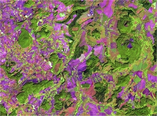
Zoom!
Wo
verläuft die ehemalige Grenze zwischen BRD und DDR?
Unterschiedliche
Bodennutzungssysteme zeigen sich in der Kulturlandschaft.
RGB=(543)
vom 11.09.1999 (Ackerflächen sind rot bis lila)
Donaumoos (Bayern): Welche Flurformen?
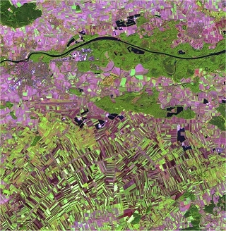
Zoom!
Unterschiedliche
Boden- und Grundwasserverhältnisse werden
in diesem Bild der
Donauniederung bei Ingolstadt sichtbar.
RGB=(543) vom 13.09.1999
(Ackerflächen sind rot bis lila)
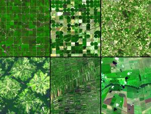
Eine Flurformen-Studie der NASA
einzeln
anklicken!
- In Minnesota (upper left) the very regular grid pattern reflects early 19th century surveying; the size of the fields is a function of mechanization and that dictates a certain efficiency.
- In Kansas (upper middle), center pivot irrigation is responsible for the field pattern.
- In northwest Germany (upper right), the small size and random pattern of fields is a leftover from the Middle Ages.
- Near Santa Cruz, Bolivia (lower left), the pie or radial patterned fields are part of a settlement scheme; at the center of each unit is a small community.
- Outside of Bangkok, Thailand (lower middle), rice paddies fed by an extensive network of canals that is hundreds of years old, appear as small skinny rectangular fields.
- And in the Cerrado in southern Brazil (lower right), cheap cost of land and its flatness have resulted in enormous farms and large field sizes.
Each ASTER sub-image covers an area of 10.5 x 12 km.
NASA/GSFC/METI/ERSDAC/JAROS,
and U.S./Japan
ASTER Science Team
zurück zu Teil 1: Entstehung von Siedlungsformen
weiter zu den Siedlungstypen, Teil 3
![]()